Building & Bylaw ServicesCorporate Services Current PlanningDrinking Water & Watershed ProtectionEconomic DevelopmentEmergency ServicesEnergy & SustainabilityGIS/MappingLong Range PlanningParksRecreationRegional TransitSolid Waste and RecyclingWastewater ServicesWater & Utility ServicesServices by Others
Beachcomber Regional Park
Small but precious, this accessible one hectare oceanside park was acquired by the RDN in 1964. It's situated at the end of Nanoose's Beachcomber Peninsula and offers spectacular views west across Craig Bay to Parksville and Mount Arrowsmith and north across the Strait of Georgia to the mainland coastal mountains. At low tide, large flat rocks are exposed which makes great territory for exploring and tide pool investigating. Away from the sea, enjoy short walking trails through arbutus, Douglas-fir and Gary Oak woodland.
things to do
Walking, beach exploring
Walking, beach exploring
how to get there
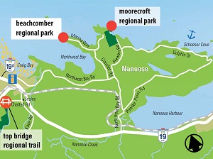
Take Northwest Bay Rd (off either Hwy19 or Hwy 19A) and proceed to Claudet Rd and Marina Way.
Location Map


